Document
Investigation Report into Flooding Incident of 21st January 2021 Goshen Park, Skewen
Introduction
An investigation has been undertaken by the Council as Lead Local Flood Authority in response to the flooding that occurred at Goshen Park, Skewen on 21st January 2021. This report is a summary of the investigation and includes the relevant information required to meet the statutory requirements placed upon the Authority under Section 19 of The Flood and Water Management Act 2010. Information regarding the duties and responsibilities placed on a Lead Local Flood Authority to investigate flooding can be found in Appendix A – Duty to Investigate.
One of the requirements of Section 19 is that the report must identify which Risk Management Authorities (RMA) have relevant flood risk management functions. Appendix B – Risk Management Authorities Responsibilities provides a summary of the roles and responsibilities of the RMA’s within Neath Port Talbot.
Through the investigation process, it was determined that the relevant RMA’s for the flooding that occurred at Goshen Park are:
- NPTCBC as Lead Local Flood Authority
- NPTCBC as Highway Authority
- Dwr Cymru Welsh Water as the sewerage undertaker
- The Coal Authority
The flooding occurred on Thursday 21st January 2021 as a result of a disused mineshaft blow out.
Actions have already been undertaken by NPTCBC to reduce the flood risk in the area. All actions remaining are being undertaken by the Coal Authority.
Flood Incident
2.1 Location of flooding
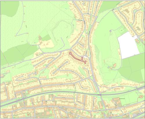
The site is located within the town of Skewen, Neath Port Talbot. Goshen Park is located in electoral ward of Coedffranc North which is located in the West of Neath Port Talbot County Borough. Easting: 272913, Northing: 197831.
2.2 Rainfall event and analysis
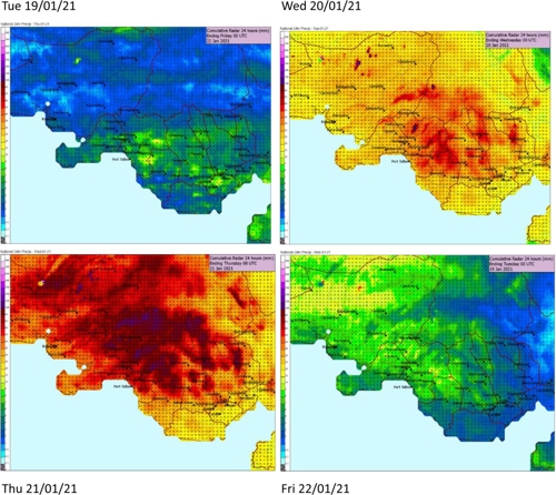
Leading up to the event sporadic rainfall fell across the county borough, peaking in intensity at 18:00 hrs on 20/01/2021. The average rainfall in the 24-hr period on 20/01/2021 was approximately 55mm.
The average levels of rainfall that fell across a 4-day period are displayed in figure 2. It shows how the sporadic rainfall started on Tuesday increasing intensity leading up to the event, figure 3 shows the rainfall in a bar chart.

2.3 Flood extent
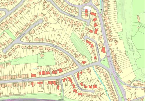
The flooding incident at Skewen occurred on the 21st of January 2021 as a result of surface water flooding emanating from a disused mineshaft at 1 Goshen Park. The topography of the local area led to flood water flowing down Drummau Road, through the back gardens on Sunnyland Crescent before accumulating on Dynevor Road and the neighbouring streets which are low spots in the locality.
A total of 55 properties suffered internal flooding in and around Goshen Park.
- Goshen Park – 12 Properties
- Sunnyland Crescent – 4 Properties
- The Highlands – 1
- Dynevor Road – 17
- Jubilee Crescent – 19
- Llys Y Graig – 2 (flats)
Figure 2 - 5 below illustrates those properties internally flooded as a result of surface water flooding.
2.4 Site characteristics
The residential area of Goshen Park and the immediate surrounding area doesn’t form part of any main river catchment.
From the uppermost catchment, the topography of the site is characterized by steep gradients, with the highest point at Moel Darran being 229m Above Ordinance Datum (AOD). The site gradually descends from Drummau Road to New Road, which has is approximately 20m AOD.
It must be noted that there are over 15 old mine entries within the immediate vicinity of Goshen Park, along with coal outcrops and past shallow coal mine workings.
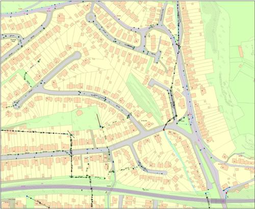
2.5 drainage networks
Figure 5 identifies the surface water and land drainage networks in the vicinity of the flooding incident. The majority of these systems forms part of Neath Port Talbot Council responsibility for maintenance, however some sections not in the adopted highway is of riparian ownership.

2.6 Investigation findings
The water volume in the mine system beneath Goshen Park reached a point where capacity was exceeded on 21st January 2021. This resultant ‘blow out’ released an excessive volume of water which the surrounding surface water drainage network was unable to effectively convey, this resulted in many homes becoming inundated with water, causing disruption and upheaval for many local residents.
NPTCBC officers and operatives were first on the scene and immediately identified the source of the flood water. The Coal Authority were informed and an emergency team was deployed to the area. Over the hours, days, weeks and months after the incident the Coal Authority and the Lead Local Flood Authority worked closely together to contain the water and convey it to the nearby ordinary watercourse via numerous means, including overland relief pipework and surface water pumps.
Whilst the Council undertook some emergency action to assist with mitigating flood risk in the short term, to reduce the flood risk effectively and in the longer term, a remediation scheme needed to be developed by the Coal Authority, which is now underway.
Investigations undertaken by both authorities helped improve the understanding of what caused the incident that also led to further repairs and improvements to the local drainage network. The Coal Authority took a lead on investigations at the ‘Blow Out’ location as they developed a mine water remediation scheme to protect the residents from future flooding.
For further information please see;
https://www.gov.uk/environment/coal-water-management
Correspondence is still ongoing between the Coal Authority and the Council as lead Local Flood Authority as the Coal Authority undertakes the different phases of construction works.
Recommended actions
The actions contained within Table 1 are recommended actions to be taken forward by the relevant RMA or property/landowner.
| No. Action by | Action | How it will be achieved |
|---|---|---|
| 1. The Coal Authority | Design and Develop a Mine Water Flood Remediation Scheme |
|
| 2. LLFA | Undertake a thorough S21 asset survey in Skewen |
|
The recommended actions that have been identified to be undertaken by RMA’s will be monitored for progress by NPTCBC as the LLFA.
Appendicies
Appendix A - Duty to Investigate
The Flood Risk Regulations 2009 (FRR 2009) and the Flood and Water Management Act 2010 are two relatively new legislative documents that recognise NPTCBC as the Lead Local Flood Authority (LLFA) for the area. This has placed a number of flood risk management duties and responsibilities on NPTCBC. In particular, Section 19 of the Flood and Water Management Act 2010 places a duty upon NPTCBC to undertake investigations into flood events to the extent that it considers necessary.
Flood and Water Management Act: Section 19 - Local authorities: investigations
(1) On becoming aware of a flood in its area, a lead local flood authority must, to the extent that it considers it necessary or appropriate, investigate-
- which risk management authorities have relevant flood risk management functions, and
- whether each of those risk management authorities has exercised, or is proposing to exercise, those functions in response to the flood.
(2) Where an authority carries out an investigation under subsection (1) it must-
- publish the results of its investigation, and
- notify any relevant risk management authorities.
Flood and Water Management Act (2010), S.19, c.29, London: HMSO
A ‘Risk Management Authority’ (RMA) means:
- Natural Resources Wales (NRW)
- a lead local flood authority
- a district council for an area for which there is no unitary authority,
- an internal drainage board
- a water company, and
- a highway authority
When considering if it is necessary or appropriate to investigate a flood event within its area, NPTCBC will review the severity of the incident along with the number of properties affected and the frequency of such an occurrence. The Council’s Local Flood Risk Management Strategy sets out the criteria to be used when considering a Flood Investigation Report.
An investigation will normally be carried out where at least one of the following conditions is met:-
- Risk to life as a result of flooding
- The internal flooding of five or more properties has been experienced in one event
- Critical infrastructure would be affected
- Internal flooding of one property has been experienced on more than one occasion
- There is ambiguity as to the source or responsibility of the flood incident
Appendix B - Risk Management Authorities Responsibilities
RMA’s in Neath Port Talbot have responsibilities in relation to flood risk management. Table 2 below identifies numerous sources of flooding and the RMA that has responsibility and flood risk management functions relating to a particular source of flooding.
| Flood Source | Natural Resources Wales | Lead Local Flood Authority | Water Company | Highway Authority | Coal Authority |
|---|---|---|---|---|---|
| Main River | * | ||||
| Ordinary Watercourse | * | ||||
| Surface Water | * | ||||
| Surface Water Originating on the Highway | * | ||||
| Sewer Flooding | * | ||||
| The Sea | * | ||||
| Ground Water | * | * |
The general responsibilities placed upon RMA’s in relation to flood risk management are outlined below.
Natural Resources Wales
Natural Resources Wales (NRW) is responsible for managing the risk of flooding from main rivers and the sea. NPTCBC works closely with NRW, especially when managing flood risk from combined sources and in the event of a large flood incident. NRW also provide a flood warning service throughout Wales in areas at risk of flooding from rivers or the sea.
Neath Port Talbot County Borough Council as LLFA
NPTCBC is responsible for managing the flood risk related to ordinary watercourses, groundwater and surface water. NPTCBC has produced a Flood Risk Management Plan (FRMP) in line with the FRR 2009 which sets out how the authority proposes to undertake this function. In addition to this and as previously stated, the Authority also has a Local Flood Risk Management Strategy (LFRMS) which was produced to meet the requirements of the FWMA 2010. There are a number of duties and responsibilities placed upon the Authority as the LLFA for the area by these two legislative documents. The Authority is also responsible for consenting works on ordinary watercourses and enforcing the removal of any unlawful structure or obstruction within the watercourse.
Neath Port Talbot County Borough Council as Highway Authority
The Authority undertakes routine maintenance on the water conveyance infrastructure contained within the highway including culvert and gully cleansing operations. These operations, together with visual inspections of the condition of such assets are undertaken to reduce the risk of flooding on the adopted highway network and adjacent land.
Dwr Cymru Welsh Water
Dwr Cymru Welsh Water (DCWW) is responsible for the supply of drinking water and for taking away, treating and properly disposing the wastewater that is produced throughout Wales. Any flooding that occurs from the overload of public sewers or burst water mains is the responsibility of DCWW.
South Wales Trunk Road Agency
The South Wales Trunk Roads Agency (SWTRA) is responsible for maintaining and managing the trunk road network throughout South Wales, including any associated drainage and flood risk assets.
Land/Property Owners
Under common law, land or property owners have rights and responsibilities relating to any watercourse that passes through or adjacent to the boundaries of their land. This means that the landowner must:
- Pass on flow without obstruction, pollution or diversion affecting the rights of others
- Accept natural flood flows through their land, even if caused by inadequate capacity downstream, as there is no common law duty to improve a watercourse
- Maintain the bed and banks of the watercourse (including trees and shrubs growing on the banks) and clear any debris, natural or otherwise, including litter and animal carcasses, even if it did not originate from their land
- Not cause any obstructions to the free passage of fish.
- Keep the bed and banks clear from any matter that could cause an obstruction either on their land, or by being washed away by high flow to obstruct a structure downstream
- Take responsibility for protecting their property from seepage through natural or man-made banks
- Under the FWMA 2010, the landowner will need consent from the Council if they want to construct a culvert or flood relief control structure on any ordinary watercourse.
- Keep clear any structure that they own such as culverts, trash screens, weirs etc